Windmills or watermills??
Sorry if this post is still a bit rough round the edges.
So far, I only have specific info about a few mills in Bedfordshire (especially Maulden, Heath & Reach).
Get a sense of place about each town in Bedfordshire - start with the list here.
A number of general online sources for information on mills: Windmill World (and Watermills at Windmill World); The Mills Archive;
For more on Bedfordshire's Windmills, visit a Wiki page here.
Steam powered mill at Ampthill - run by James Norman in 1890.
Mill powered by steam and water - at Toddington - run by Ezra Bright in 1890.
Windmills
Windmills have a longer history than you might imagine.
Here on the Muggeridge site - you can view old photos (~1933) of derelict Windmills in Bedfordshire - the nearest of interest are at Houghton Conquest & Cranfield.
Trade directories for the area tell us that there was a windmill at Barton, BEDS - run by miller George Hipgrave in 1890.
Watermills
There is a watermill at Bromham, just west of Bedford, which has been restored to working order - see their own site here. (sadly that link hasn't worked for me yet) - or view this page about the mill, where we read;
"Today, the Mill once again grinds flour, much as it used to. Millers tell the same tall stories and the machinery creaks, groans and splashes away."
A watermill at Ivinghoe (South of Leighton Buzzard), Ford End Mill, was derelict but is now restored to good working order. See this site for a great deal of interesting information Ford End Mill, and watermills in general.
Also visit YouTube for videos, or this scholastic site for a wealth of material on Watermills - it's aimed at schoolchildren, but still of interest? (This animation was especially good fun, if you are 7!)
Specific Mills: Flitton with Silsoe?
Philip Hallworth lived at Greenfield/Flitton ~1835, but I'm not sure if he was working as a miller there. He may well have been only a farmer.
Flitton Mill? Almost, but not quite! I got excited when I found this old photo on Francis Frith, but it's not quite right, being of the Mill at Flitwick. Hohum, we can use our imaginations.
The watermill at Flitwick was an overshot type mill, I've seen a photo from 1940 in The Mills Archive. Also current photos here on Geograph.
It was run by Richard Goodman in 1890 {source - trade directories}.
Greenfield Mill?
Again, not even sure if Philip Hallworth worked as a miller while he lived at Greenfield/Flitton ~1835.
The wiki page for Greenfield tries to describe the former site of a mill (it was disused by the 1960's); "Mill Lane was named after the mill which worked until the 1960s and was located at the bottom of the lane and public bridal way where a bridge now stands".
A photo is on this site AmpthillImages.com, but I can't give you a direct link. Look for OUT & ABOUT, then look in the list of towns for Flitton & Greenfield. On the first line you'll see a thumbnail of the Greenfield Mill photo, taken ~1900.
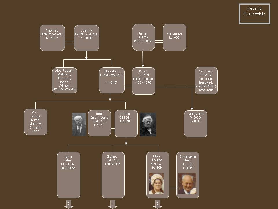
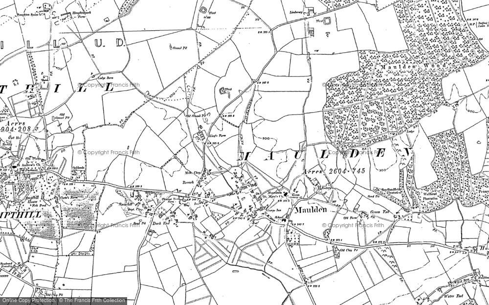
Maulden Mill:
The census returns and other records quoted below inform us quite conclusively that the Hallworth family occupied Maulden Mill, and also that the father-in-law (Pennyfather) was the Maulden miller before them.
BLARS ref PUAV 41/32 (23 Apr 1866; William Breed).
St. Luke Middx. to Maulden. Wm. Breed. In 1809, then unmarried and childless, hired as a yearly servant by Mr Pennefather of Maulden Mill at 3½gns. Served 1yr. Mich to Mich. (Mr Pennyfather was Charles' father-in-law.)
1822-28 licensing documents give us Charles Hallworth as miller of Maulden.
The 1847 trade directory lists Charles Hallworth as the Miller at Maulden Water End.
1851 census - Charles Hallworth (66, born Pulloxhill) at Mill House, Maulden. He is described as a Miller and farmer of 40 acres (employing 3 men).
Next to them (in Mill Lane) is still Thomas Hallworth, farmer of 30 acres.
His will tells us Charles Senior was a miller of Maulden who died on 8/12/1853.
In the 1891 Census of Maulden, George & Isaac continue to live together at Hall End, now also with a Chandler nephew (William, aged 45, a Gardener). Only Isaac is now given as a Miller, George presumably has retired. Were there two mills, or did Isaac work for A.C. Hallworth at Maulden Mill?By the census of 1881, the cornmiller there was Arthur Charles Hallworth (Miller & Farmer, 24, unmarried, with his unmarried sister Hannah, 40 and 2 nieces by name of Daniels (8 & 4)). The Trade Directory (later in 1881) gives us the name of Arthur C. Hallworth for the Miller in Maulden Water End.Arthur's Uncles George & Isaac Hallworth were at Hall End, Maulden in 1881. They worked as cornmillers, too. (Aged 60 & 49, both unmarried.) I can't yet find a death record for Isaac or George.
A rough match for the death of Arthur Charles Hallworth in the St.Albans district, aged 57 in the year 1917.
So, the problem now lies in being sure how many contemporary mills there were in Maulden:
The presence of a Mill at Maulden was noted even as far back as the Doomsday Book.
Letter held in the Beds Archives (R3/3721 4 March 1832), from the Duke of Bedford's steward - discusses various issues to do with land ownership in the area. Ends with:
"There are 4 mills within 3 miles of Maulden mill - best not to think of rebuilding it; miller's carelessness in flooding meadows."
Maulden on this map from 1882 - Water End clearly visible in SE corner - also Maulden Mill marked.
The British History Online site has a very useful map section where I found a very clear 1892 map of the area of Maulden Mill, and also the Dog & Badger in the North (linked here, and you can also see the modern OS map of the same area - you'll spot the modern fisheries complex, Water End Fisheries).
A clearer early map here from a collection at BLARS:

Further info from the (published 1912) History of the County of Bedford (British History Online), where the chapter on Maulden describes two mills; "The mill stands on the banks of a branch of the River Ivel below Hall End , and there was formerly another at Breach, pulled down within recent years". The first mill described is the Maulden mill shown in the map above. The River Ivel is on the current-day map, but we only see the River Flit near the mill. The other mill 'at Breach' is in the area shown on the map here, it's now called Brache.
By 1890, the Kelly's trade dir gives us a James Norman as the miller in Maulden - it's a steam-driven flour & corn mill. No others Maulden Mills are mentioned then in that text.
Images of Maulden Mill
BLARS holds a collection of glass slides or gelatine prints from the period c 1905-1920 - taken by a local photographer & rescued from a skip! Several seem to show Maulden Mill.
First we have here (BLARS ref X291/77/430) a glass slide image of Maulden Mill, which appears to show two women at the door:

Another (BLARS ref X291/77/432b) beautifully clear photograph from that collection shows the mill race, Maulden, which looks very solid:

Other photos in the collection which may be relevant:
X291/77/431b; Maulden Mill Stream
X291/77/433; brick sluice in background
X291/77/433; brick sluice in background
X291/77/499 - 2 people with possible mill in the background, Maulden.
Also the BLARS library holds 2 postcards of Maulden Mill, which seem to have been taken on the same occasion as those above.
Here the Mill Stream (BLARS ref Z520/9) given a date of c.1906. Sweet!

And then, below, Maulden Mill (BLARS ref Pu 179/83), with no date given. Could well be the same two adults, and the same child as in the postcard above?

The BLARS collection has a very bonny notebook (BLARS ref SF39/119, coded valuation notebook, from 1882) which seems to suggest the Maulden Mill/Farm is changing hands - passing from A.C. Hallworth to Samuel Brightman, according to the cover. See below for more on these names.


This notebook seems to contain valuations of the cultivated fields - assessments have to be made of crops in ground, hay stacks etc. He passed on the notebook when he passed on the tenancy?
It strikes me as strange that there's no date for each action. I'd have thought he'd want a record of which week he'd ploughed a field, or sown the seed. The numbers on the left will be acres, roods, poles, perches etc. The other columns on the right?? It seems to be in code!
The date is November 1882 - but normally a farm tenancy would change hands around September, at Michaelmas. {Thanks, Barbara's Dad for the expert help there - keeping it in the family!}
As to the crops - I can read Cauliflower, White Turnip, & Mustard. Amazing how much history can be seen in these little domestic details, like the earlier poster for the Household effects.
Who were they?
A.C. Hallworth? Thomas (eldest son of Charles) had a son named Arthur Charles, born 1857. He was the Miller living there at the time of the census of 1881.
Samuel Brightman? Barbara has a theory about who he may be. "Leonard Palmer married Eliza Brightman in 1890. Her father was Samuel Brightman, born 1822, who was a Market Gardener in the 1881 census at Hall End, and at Water End in 1891 census."
Additionally, she tells me about this line in the Bedfordshire Times, Sat. Aug. 23rd 1890:- "On Wednesday the 13th Miss Eliza Brightman, daughter of Mr. Samuel Brightman of the Mill Farm, Water End, married Mr. Leonard Palmer, farmer, of Water End."
Then at the far end of the archives, in 1911, we see a catalogue of sale of the Duke's lands - Maulden Mill was described as "Maulden Mill Farm, including disused Mill and comprising 38a 1r 38p"
Next, the Mill at Ampthill:
In the 1861 census our John Hallworth (25) & family were recorded as living at the Little Mill House, Ampthill. Was it part of Little Park?
Or was it the Doo-little Mill?? This is at Steppingley Rd, Ampthill, which is now a small business park. No sign of any watercourses in the area, so presumably this was a windmill?
A photograph on this site (AmpthillImages.com) shows us Doolittle Mill in ~1900. Look for AMPTHILL photos, then look in the list of subjects for Buildings, choose D and on the first line you'll see a thumbnail of the Mill photo.
Grange Mill near Heath & Reach:
John Hallworth & family also had a short stint at the Grange Mill, Heath & Reach. He was present for the 1871 census, but other men are recorded as miller there for the years 1862 & 1876.
{You can view the 1864 Trade Directory for Heath & Reach: here.}
The 1862 directory of Heath & Reach shows us only one miller in the town - A. Roades, Farmer & Miller. He was also there for the 1861 Census (which told us he was born in 1842). In 1864, the miller was a Thomas Holmes.
In the 1876 directory, William Edwin was the miller. Was our John an assistant miller, or did his time as miller fit in between Roades & Edwin?
The lack of any other Millers in the pages of the 1871 Census suggest to me that John was the Miller on his own.
The births of Eliza & John's children provide a few clues. Our Charles, their son, was born in Ampthill in 1864. Their next children, however, were all born in Heath & Reach until the birth of Philip in Swallowfield, in ~1875. So certainly they were at Grange Mill from 1868 (possibly 1866 if Jessie is theirs!) until 1873.
Kelly's Historical directory also tells us that Heath & Reach was the source of some of the sand used to make the glass for Crystal Palace, for 1851.
The Bedfordshire Archive (BLARS) have a huge online resource folder about Heath & Reach - it includes a page collecting the old maps, of which this one from 1901 (25" scale) clearly shows Grange Mill as a watermill. Grange Mill can be seen on Google Maps here; on the Ouzel River, next to modern-day Rushmere. This Geograph page tells us that "At Old Linslade, the original course of River Ouzel is reduced to little more than a stream, with much of the river's flow being diverted to feed Grange Mill to the north".
You can also view a page from the BLARS archives on Grange Mill here, and a page about the old local school here.
Heath & Reach was a town of 1000 souls in the year 1871.
There was also a windmill at Heath & Reach - run by Holmes in 1890, and another windmill at Heath & Reach - run by Bates in 1890 (see Council Archive piece here).


No comments:
Post a Comment
Have your say - but it may take a while before it appears. Sorry - I need to do this, because I took out the security steps to make it all easier and allow anonymity...but now I need to moderate!! Cheers, Lisa